Monday, May 9, 2011

Mohale Dam


It was nice to sleep in on Saturday after what seemed like an extraordinarily busy week at the clinic. It seems they overbooked patients last week in light of the upcoming network BIPAI meeting, which meant that we were seeing over 130 patients daily. Despite our best efforts for a quick turnover, the lobby constantly looked like the TCH ER waiting room back home (translation: a complete disaster zone with children sprawled over every visible tile on the floor while their mothers/grandmothers impatiently waited on the benches, giving us meaner looks with every hour that passed). Feeling like we deserved another outing for our hard work, we booked one of the clinic drivers for a day trip to Mohale this weekend.

My med student roommate and I baked some fresh fruit muffins in anticipation of our trip and bid goodbye to our two other roommates whom were scheduled for departure back to the U.S. that day. When Jamie (our British counterpart) arrived with Limpho, the driver, we jumped in the little white VW that felt so familiar after our adventure last weekend. Much to my surprise, my sunglasses were still sitting in the backseat (I had only noticed they’d been missing that morning…oops!). Limpho (pronounced “Dim-poh”) likes to listen to his music at several decibels above any of our comfort levels, so we quickly abandoned our futile efforts to carry on a conversation by shouting back and forth to each other, and instead sat back, ate our homebaked treats, and jammed out to his eclectic mix of traditional Basotho music/gangster rap/Black-Eyed-Peas/slow R&B hits from the early 90’s.

Views from the drive up


Remote Basotho village on the side of a mountain (each neighboring village is about 15 kilometers from each other)
Similar to last week, we had amazing views of the scenery and villages sprinkled along the foothills as we climbed several hundred feet around the winding roads of the mountains. We arrived in Mohale a little after noon and drove straight to the main attraction - the second phase of the Lesotho Highlands Water Project (LHWP) – also known as the Mohale Dam.


According to The Lonely Planet Travel Guide, "The LHWP is an ambitious scheme developed jointly by Lesotho and South Africa to harness Lesotho’s abundant water sources to provide water to a large tract of Southern Africa and hydropower to Lesotho. The project, being implemented in stages until 2020 will result in several major dams (two of which have been completed, the Katse and the Mohale Dam) with approximately 200km of tunnels interconnecting them."


"The immediate effects of this development include vastly improved roads and telecommunications in the interior of the country, benefiting the residents of many remote villages. However, there are also detrimental effects: flooding of significant portions of Lesotho’s already scarce arable land and potential silting problems; relocation difficulties and corruption prosecutions of international companies involved in the project."


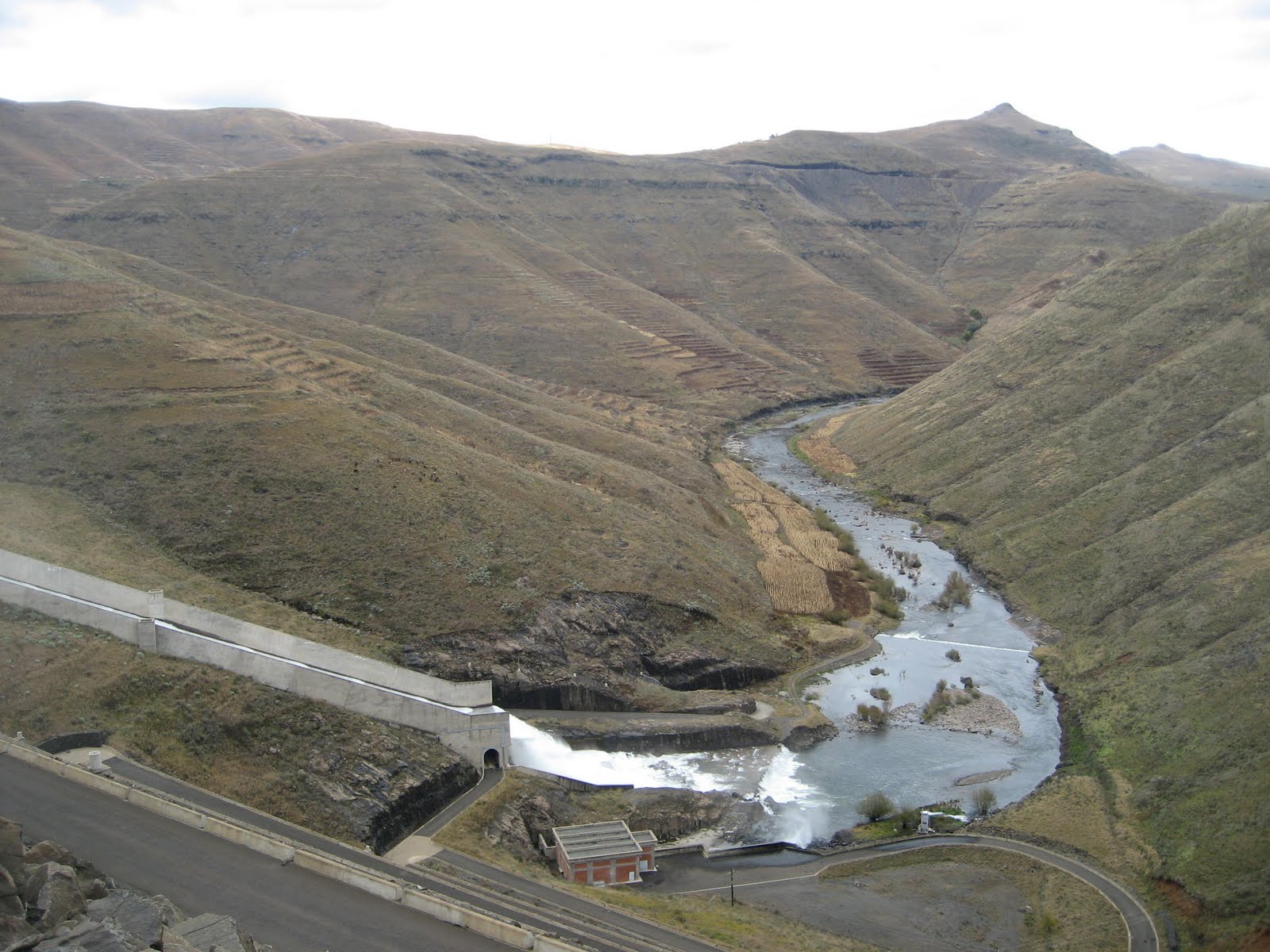
The Mohale Dam was built across the Senqunyane River. It is an impressive 145 meter high, rock filled dam that was completed in 2004. There are commanding views of the lake and massive mountains beyond. There is a Mohale Tunnel through which water can flow for 32km between Mohale and Katse Dams.

When we arrived, we were actually able to arrange a private tour of the facilities for only R10 (about $1.25 USD), which took us inside and around key aspects of the dam.

Our driver, Limpho (far right) trying to negotiate a tour with the facility employees
What was most amazing to me was that while on one side of the dam the lake appeared so tranquil, the other side demonstrated the immense, sheer force at which the water spilled out of the dam. As the water crashed onto the rocks, it splashed a wide diameter around the area, effectively soaking us as though we were standing at the bottom of a waterpark slide.


Afterwards, we drove back up the winding roads and stopped at the Mohale Lodge where we had lunch. Although there were several tantalizing items on the menu, we all ended up ordering the daily special – braised lamb chops with a red wine reduction, and a side of French fries with paprika seasoning. Very delicious. Feeling adventurous, I ordered one of the local beers, Maluti (Sesotho word for “mountain”), to accompany my meal. It tasted a bit like Bud Light, though I’m no beer connoisseur by any means, so I always compare beers to Budweiser brands. I have found that the red wine here is actually quite good, so this has been my beverage of choice whenever we go out.
If you strain a bit, you can see the nice rainbow at the top left side of the hill - a nice ending to our day :)
 Anyways, we arrived back home and took a nice hot shower (now that there’s only 2 of us, there was no frantic rush to shampoo and be out of the shower within 10 minutes for fear of the hot water running out) before climbing in bed.


Wednesday, May 4, 2011

Spotlight on Lesotho


I have now been in Lesotho for a week and during this time, I have learned a few basic and interesting facts:
The nation's flag, adopted in 1987, has diagonal stripes of white, blue, and green.
White is symbolic for peace ( khotso ), blue for rain ( pula ), and green for plenty ( nala ).

  • The Kingdom of Lesotho (~11,720 sq miles - about the size of Maryland) was formerly known as Basutoland prior to its independence from the UK in 1966. 
  • Population: 2 million (as of 2010)
  • Capital: Maseru
  • The currency is Maloti, which is interchangeable with the South African Rand (approximately 7 Rand = $1 USD).
  • The time zone is 7 hours ahead of Central U.S. 
  • Predominant Religion is Christianity (majority Roman Catholic, as evidenced by the fact that there are villages named "Nazareth" and "Bethlehem" and a main road named after Pope John Paul II)


  • Lesotho is a kingdom, first established by King Moshoeshoe I. His son is the current monarch, (King Letsie III) but does not hold any legislative or executive authority; instead, this is headed by a prime minister (Bethuel Pakalitha Mosisili) with a parliamentary constitutional government structure.
  • Culture: Most people living in Lesotho identify themselves as "Basotho". The primary languages are Sesotho and English. The name Lesotho is actually translated into “people who speak Sesotho.” The literacy rate is actually among the highest in developing countries (85%), with females achieving higher rates than males.
  • Some delicious "Fat Cakes," now part of our weekly tradition. Fried, slightly sweet dough...Mmmm!
  • Food: The staples of Basotho food include cornmeal porridge ("pap-pap"), accompanied by pea sauce or green vegetables. On special occasions, chicken is added, and during celebrations, cows are slaughtered and feasted upon. Several stands along the road also sell "fat cakes" or flavored, colorful maize treats for children for a few cents. 
  • Geography: The regions are divided into “lowlands” and “highlands” but even the “lowlands” are all above 4.500 feet above sea level, making Lesotho the country with the highest altitude in the world (which also creates cooler temperatures throughout the year as compared to the rest of the continent, reaching well below freezing during winter). 
  • Seasons include:
    • Summer (December - February)
    • Fall (March – May)
    • Winter (June – August)
    • Spring (September-November)

The Basotho hat, a conical woven hat with a distinctive topknot, is a symbol of Lesotho's unification.
It depicts a mountaintop, which is visible from the fortress and tomb of Moshoeshoe I  near Maseru.
Both men and women invariably wear the wool Basotho blanket as a cloak, regardless of the season. The careful selection of color and pattern allows for individual expression

  • Economy: The main industries in the country involve diamond mining and water exportation (to South Africa) as well textile and agricultural exports.  However, 40% of the population lives below the poverty line. A contributing factor to this problem is that the main workforce (18-35year olds) is plagued by an HIV / AIDS epidemic that has not only decreased productivity, but has also left behind an increasing number of orphans or abandoned children. Infant mortality rates have been quoted between 5-8% annually.
  • Though HIV was identified in the early 1980’s it was not until 2005 that anti-retroviral therapy became widely available in Lesotho. Since then, the implementation of HIV / AIDS prevention and treatment campaigns have dramatically decreased the amount of associated deaths.
  • However, Lesotho remains the country with the 3rd highest HIV/ AIDS prevalence worldwide, with approximately 24% of the country affected. This is reflected in the almost 0% net annual population growth and average life expectancy of 40-50 years.
  • International organizations involved locally include: UNICEF, The Elizabeth Glazer Foundation, The Clinton Foundation, Bristol Meyers Squibb, Baylor College of Medicine / Texas Children’s Hospital and a few others, but the availability of medications, health professionals, and community clinics is still extremely scarce. The ratio of physicians to patients is approximately 5 to 100,000.
  • There remains much work to be done…
  • For more info, visit: 

Monday, May 2, 2011

Malealea

Spectacular view as we neared Malealea

As I held on to the worn, leather saddle with an iron grip that was sure to leave at least semi-permanent imprints of my fingers on it, I closed my eyes and braced myself for the next adrenaline filled jump that was to follow in a sequence of descents around the mountain we were trekking through. Perhaps I had signed up for a little more adventure than I had bargained for…


Just a couple of hours earlier, I had been impatiently awaiting our arrival into the neighboring village of Malealea, located a mere hour and a half from Maseru. The drive had been pleasant and uneventful until the last 10 kilometer stretch in which the paved road turned into a hostile dirt path full of potholes and loose gravel, forcing our driver to slow down to a painfully slow speed so as to avoid a breakdown in the late model VW we rode in. We made it to Malealea Lodge at approximately 11am on Saturday and eagerly registered for the pony trek that would lead us to the famed Botso’ela Waterfall as our final destination. When our “ponies” arrived, I was introduced to Jupiter, the “naughty” pony, who stood out among his four-legged friends by the bluish hue of his coat rather than the traditional caramel brown. Throughout the course of the day, he would indeed live up to his reputation as the rebel of the group, taking me through alternate routes that struck his fancy. What the creatures shared in common, however, was that they were full sized horses, albeit a bit malnourished, but horses, and not ponies (I had been picturing the miniature Shetland ponies at petting zoos). Similarly, I came to find out that “trekking” was actually a euphemism for “mountain climbing on horseback along dangerous and grueling terrain.”

My trusty sidekick, Jupiter, and me heading off on our journey

Traditional Basotho huts

Apparently the Lodge has a sense of humor...

More Basotho huts (each furnished with 2 twin beds and an en-suite, quite cozy acommodations)

The other kind of housing in Lesotho, a rectangular, stone-lined frame with a sheet of aluminum as the roof
Anyways, I packed my lunch into the saddle bag and signed the mandatory waiver (feeling a momentary tinge of regret for not purchasing the recommended international medical insurance including emergency air evacuation in case of an accident) before mounting on board and heading into the wilderness with two of my roommates and our guide. We started out on flat plains, admiring the row of Basotho huts and corn fields as we gradually made our way to a precipice that our horses were clearly uncomfortable jumping down. Our guide pulled them along manually and from there it was as if the horses were on auto-pilot, following the vaguely discernible paths of travelers before us with minimal guidance. 

At first, it appeared that some of the nearly vertical descents would surely catapult me off the top of the horse while some of the climbs were onto ledges that were so narrow I had to hold my breath for fear that any sudden movement would cause Jupiter to lose his balance and send us both spiraling down the side of the mountain to meet a grim fate. I was quickly reminded of the importance of leaning back during the trip downward and leaning forward as we climbed up the mountain, while never for a second letting go of the saddle – basics of horsemanship, but long-forgotten techniques I had last used several years ago at best.

At the lowest level of the ride, following the ravines

Rocky uphill climb

And the winding uphill climbs continued for several hundred meters...

Once I placed my full trust in Jupiter and shifted my weight with his movements, though, the rest of the ride was wonderful! The majestic backdrop of rugged mountain peaks above us and the shimmering snake-like ravines below us were absolutely magnificent - yet also so still and peaceful I could hear the flapping of the birds’ wings and the rustling of the grass as the sheep and cattle grazed from several hundred feet away - the only indicators that I was not the only living being in this world. And the air! At that altitude, the air was refreshingly pure and smelled of a soothing mixture of natural herbs, something I wish I could bottle up and bring home with me as a reminder that a greener place exists outside the concrete jungle of the medical center that has become my habitat.

Looking down at the distance we'd climbed (the ravines are now a distant sight)

Pictures don't do these views justice

 After about 2 hours of maneuvering my camera with one hand in a desperate attempt to take in the beautiful vistas while hanging on to dear life with the other hand, we arrived at our destination...almost. From here we dismounted the horses and met our "tour guide" for the remainder of the journey – a 10 year old child dressed in a tan jumpsuit who motioned us to follow him as he quickly jumped down the rocky trail in the direction of the waterfall. It was then that I truly appreciated the ability of our horses to navigate the terrain; all of us kept slipping and sliding, trying not to sprain our ankles or fall on top of each other on our way down as we tried to catch up to the boy. I heard the water much before I actually caught a glimpse of it and the suspense grew exponentially until we were finally faced with the sheer splendor of the Botso’ela Waterfall. The weather through the ride had been perfect, full of sunshine and clear skies, but now, the mist of the water and the shade provided by the surrounding rock formations made for a very chilly spot, where we zipped up our jackets and posed for fun pictures as our “guide” joined a couple of other children that made up a band. It appears they play for tourists while they have lunch by the waterfall - for a nominal tip, of course. We un-wrapped our sandwiches and cheered the band along as we ate a much deserved meal perched on a cold rock, taking it all in.

The Botso'ela Waterfall

One of my roommates and me

The "band" that played for us as we ate our lunch by the waterfall

Crawling uphill on foot

The ride back was much less grueling but still involved a couple hours’ worth of uphill and downhill climbing; by the time we made it back to Malealea Lodge, my entire body was aching for a hot shower and massage. I definitely now know what it means to “walk like a cowboy…” Haha. Upon nearing the Lodge, the path was lined by young children running towards us and waving, as if we were heroes returning from a long battle. I laughed silently because I felt nothing like a hero but I did feel proud that we had made it through our adventure in one piece…and we were now newly self-proclaimed pony trekking experts! Not bad for our first weekend in Lesotho. I am looking forward to next weekend when we can do it all over again in Semongkong! 


Happily Ever After ?

Memorabilia in the Westminster Abbey Gift Shop


So last Friday, the event that many females around the world were eagerly anticipating finally took place - The Royal Wedding! It was quite the celebratory occasion at our clinic as most of the physicians gathered around my laptop in the upstairs library to watch the event unfold. As we are conveniently located on this side of the pond at the moment, we actually witnessed the "live" broadcast at noon. Unfortunately, the internet video streaming quality was sub-optimal and inserted several extra "pauses" throughout the ceremony, leaving us with a grainy view of the dress and facial expressions. 


Royal Wedding Event Poster on the Buckingham Palace Gate


Nonetheless, it was nice to see a fairy tale come true for an ordinary girl like Kate Middleton to marry a real prince (well, perhaps being the daughter of billionaire parents doesn't entirely qualify as "ordinary" but never mind that little detail). We were a bit confused by the land titles vs the royal titles (duchess vs princess?) and our British colleague was of little help to us in discerning this matter... In any case, her dress was modest, yet elegant and timeless, and she looked absolutely beautiful - this theme clearly reverberated throughout the rest of the ceremony. Some girls have all the luck... Prince William looked very dapper, too, although he appears to be having some hair thinning issues - nothing he can't pay to be fixed, I'm sure. And those hats that some of the guests wore...I'm not so sure about what kind of statement they were trying to make.  Anyways, here are some pics from my brief encounter with the preparations for the big day:

Look-alike Prince William and Kate making a public appearance outside Westminster Abbey

Listing of the Royal Wedding events (sorry can't see clearly due to glare)

Private stands set up for VIP guests along the Buckingham Palace roundabout to witness procession to the reception


Stands set up outside the entrance to Westminster Abbey for the church ceremony

Where the reception took place
So will William and Kate live happily ever after - who knows?! But a girl can always dream...   :)